|
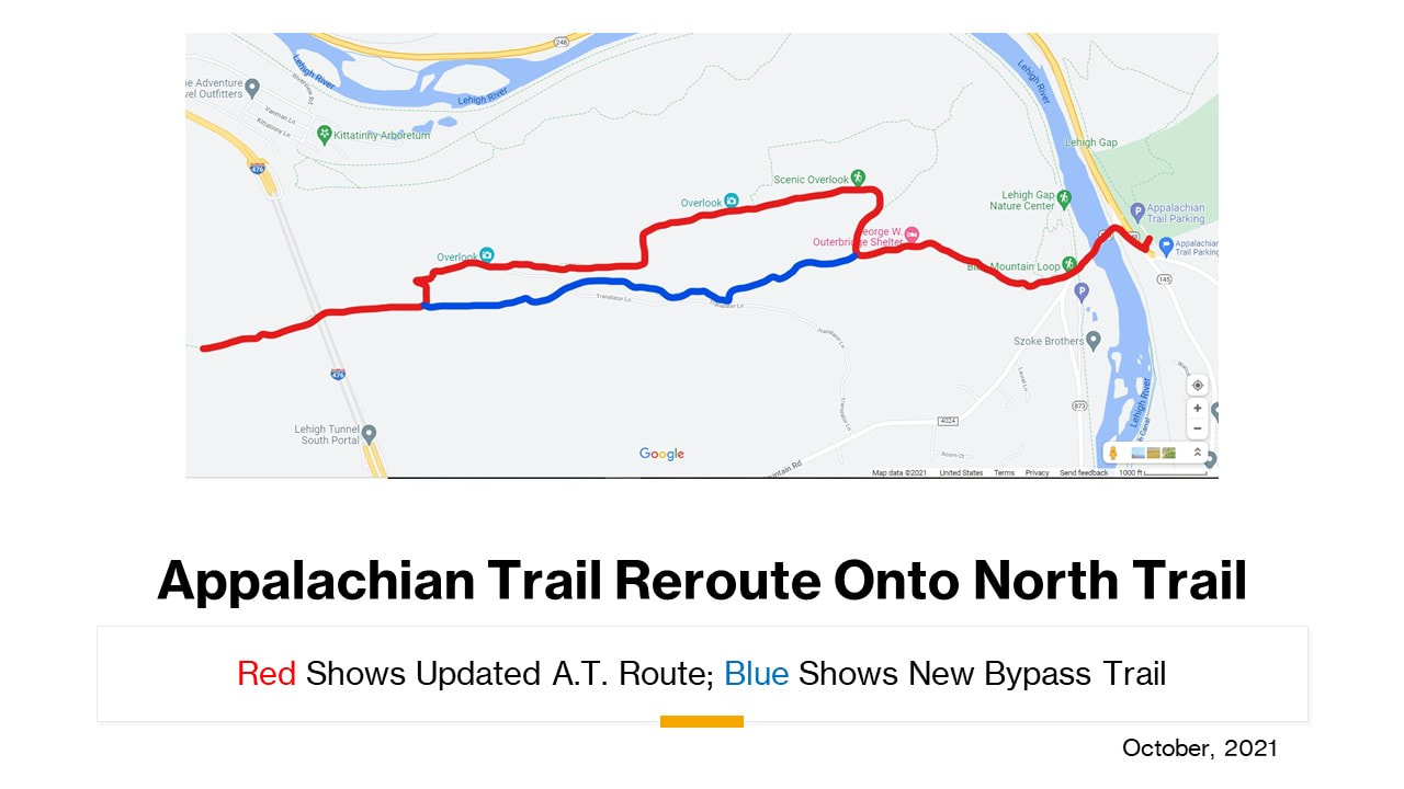
The Appalachian Trail Section Committee of Keystone Trails Association has completed a reroute of the Appalachian Trail onto the former route of the North Trail. This A.T. reroute is in eastern Pennsylvania just west of the Lehigh River and approximately three miles southwest of Palmerton, PA, along the border of Lehigh and Carbon Counties. It was completed on October 16, 2021. The path of the reroute is shown on the enclosed graphic of a Google Map. The reroute is 2.2 miles in length and will add 0.7 mile to the A.T. Jim Foster, Chair of the KTA A.T. Section Committee, said: “We’re excited to announce this portion of our reroute. Hikers in the Lehigh Valley have long known about the spectacular views of the Lehigh Gorge available on the North Trail. Now, hikers from all over the world who hike the Appalachian Trail will be able to see it. Our group has made several improvements to the North Trail during 2021. We think it’s time now to show off this great trail to the world, rather than waiting for the entire rerouted Trail to be completed.” Scenes from the new Appalachian Trail, formerly the North Trail The rerouted trail will be a return for the A.T. For many years the current North Trail was the path of the A.T. It was moved to the present path because of the environmental damage caused by the former zinc processing plant in Palmerton. Much of that damage on both sides of the Lehigh River has been remediated under the federal Superfund law. The portion from which the A.T. is being rerouted will be maintained as a side trail and is called the Bypass Trail. Thanks to everyone who submitted suggestion on what to name the new side trail.
This reroute is the first phase of a larger planned reroute of the A.T. within the KTA section. The remainder of the reroute will take place after a new path for the trail has been built. A portion of that new trail has been completed just west of Lehigh Furnace Gap by the Appalachian Trail Conservancy’s Mid-Atlantic Trail Crew. More trail building will take place over the next several years. “At this point we do not have a timeframe for the additional reroutes”, Foster said. “We will announce additional reroutes as they become ready.” HERE is a link to four maps that show all of the planned relocations. Additional information on the reroute is available on the Section Committee’s website, https://ktalehighgapat.weebly.com/ Questions may be submitted to [email protected] The Appalachian Trail Section Committee of Keystone Trails Association is one of 31 clubs that maintains the Appalachian National Scenic Trail, America’s best known and most heavily used long distance hiking trail. The A.T. is the largest hiking-only footpath in the world, extending for approximately 2,190 miles from Mt. Katahdin, Maine to Springer Mountain, Georgia. KTA’s A.T. Section Committee maintains the A.T. in the Lehigh Valley of Pennsylvania from Lehigh Furnace Gap to Little Gap, plus three adjoining trails, the North Trail, the South Trail and the Winter Trail. Keystone Trails Association, based in Mechanicsburg, PA, is Pennsylvania’s statewide hiking and trails organization. KTA’s main website is https://www.kta-hike.org/
7 Comments
Tom Anderson
9/12/2021 11:47:31 am
Keep informed
Reply
Joe Taeffner
9/12/2021 12:28:39 pm
Maybe South Trail?
Reply
AZHAR IQBAL
9/12/2021 12:32:30 pm
How to access this newly planned Lehigh mountain trail. Is there a parking area nearby ?
Reply
Brian C
9/14/2021 01:35:16 pm
Same as currently. Small lot on 873 or for day hikes you can start at Lehigh Gap Nature Center to connect to the AT.
Reply
Jim Foster
9/19/2021 08:48:56 am
There are several options. Park on the west side of the Lehigh at either the Lehigh Gap Nature Center or a small A.T. parking lot off Route 873. Hike south-westbound on the A.T. about a mile up a fairly rocky stretch. The blue blazed North Trail (soon to become the A.T.) begins shortly after the Outerbridge shelter. There is a larger, better maintained parking lot on the other side of the Lehigh just off Route 248. Take the A.T. across the bridge and climb past the Outerbridge shelter. Another way is to take Mountain Road west of the Lehigh River. Turn right at Ashfield Road and follow it to the junction with the A.T. on top of the mountain. Take the A.T. about 2 miles northeast to the junction with the present North Trail.
Reply
Kerry "Scribbles" Smtihwick
9/18/2021 08:56:17 am
I think Gorge View Trail would be appropriate
Reply
TS
9/19/2021 05:22:03 pm
ZINCNOTAT
Reply
Leave a Reply. |
NEWS |


